
Latest Version
Version
7.7.0
7.7.0
Update
March 05, 2025
March 05, 2025
Developer
ATLOGIS Geoinformatics GmbH & Co. KG
ATLOGIS Geoinformatics GmbH & Co. KG
Categories
Maps And Navigation
Maps And Navigation
Platforms
Android
Android
Downloads
0
0
License
Free
Free
Package Name
US Topo Maps
US Topo Maps
Report
Report a Problem
Report a Problem
More About US Topo Maps
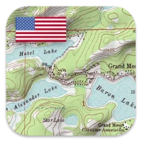
Easy to use outdoor navigation app with free access to the best available maps and aerial imagery for the USA.
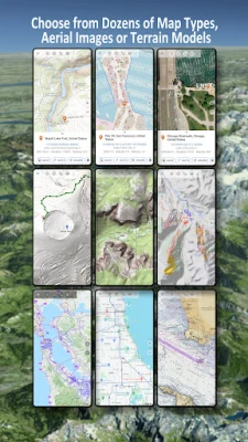
Choose between 30+ map layers (topos, aerials, sea charts, ...) to plan the perfect trip and
turn your Andoid Phone/Tablet into an outdoor GPS for offline trips into the backcountry.
Add easily maps from other sources (GeoPDF, GeoTiff, Online Map Services like WMS, ...)
Available basemap layers for USA:
• USGS National Map Topo
• USGS National Map Imagery Topo
• USGS National Map Imagery
• USGS NAIP HiRes Imagery
• USGS Topo traditional DRGs: Seamless coverage of topo maps of the USA at Scales 1:250.000, 1:100.000, 1:63.000 and 1:24.000/25.000
• FSTopo Forest Maps
• NOAA Nautical RNC Charts
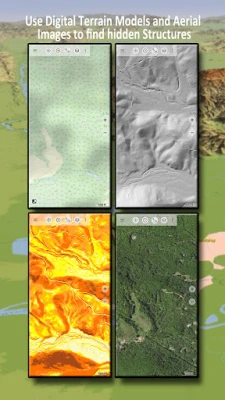
• National Elevation Maps (Hillshade, Slope Map, Aspect Map)
Worldwide basemap layers:
• OpenStreetMaps (5 different map layouts), also downloadable in space saving vectorformat
• Google Maps (Satellite images, Road- and Terrain-Map)
• Bing Maps (Satellite images, Road-Map)
• Earth At Night
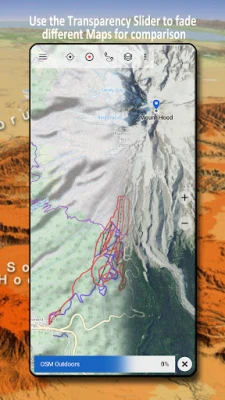
Configure a basemap layer as an overlay and utilize a transparency fader to seamlessly compare maps with each other.
Add maps from other sources:
• Import raster maps in GeoPDF, GeoTiff, MBTiles or Ozi (Oziexplorer OZF2 & OZF3)
• Add web mapping services as WMS or WMTS/Tileserver
• Import OpenStreetMaps in Vectorformat, eg complete USA for just some GBs
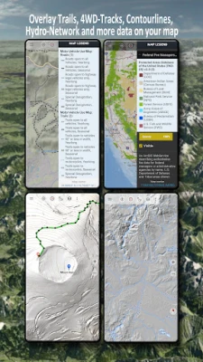
Available US map Overlays - add additional information to any other base map:
• Public Land Ownership (PAD-US 3)
• National Hydrographic Dataset
• Motor Vehicle Use Map (USDA)
• Elevation Contourlines
• 4WD Trails
• Trails
• Roads, Railroads, Airports
Available worldwide overlays:
• Hillshading overlay
• 20m Contourlines
• OpenSeaMap
There is no perfect map. Toggle between the different map layers or use the compare maps feature to find the most interesting route. Especially the old traditional DRGs contain many small pathes or other features that are missing on modern maps.
Main features for outdoor-navigation:
• Download map data for OFFLINE USAGE
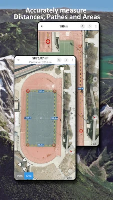
• Measure pathes and aereas
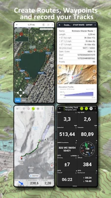
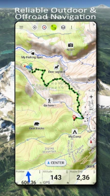
• Create and edit Waypoints
• GoTo-Waypoint-Navigation
• Create and edit Routes
• Route-Navigation (Point-to-Point Navigation)
• Track Recording (with speed, elevation and accuracy profile)
• Tripmaster with fields for odometer, average speed, bearing, elevation, etc.
• GPX/KML/KMZ Import/Export
• Search (placenames, POIs, streets)
• Get elevation and distance
• Customizable datafields in Map View and Tripmaster (e.g. Speed, Distance, Compass, ...)
• Share Waypoints, Tracks or Routes (via eMail, Dropbox, WhatsApp, ..)
• Use coordinates in WGS84, UTM or MGRS/USNG (Military Grid/ US National Grid),
• Track Replay
• and many more ...
Use this navigation app for outdoor activities like hiking, biking, camping, climbing, riding, skiing, canoeing, hunting, snowmobile tours, offroad 4WD tours or search&rescue (SAR).
Add custom waypoints in longitude/latitude, UTM or MGRS/USNG format with WGS84 datum.
Import/Export/Share GPS-Waypoints/Tracks/Routes in GPX or Google Earth KML/KMZ format.
See animated NEXRAD rain radar to make accurate predictions when raining will start/stop
Please send questions, comments and feature requests to [email protected]
turn your Andoid Phone/Tablet into an outdoor GPS for offline trips into the backcountry.
Add easily maps from other sources (GeoPDF, GeoTiff, Online Map Services like WMS, ...)
Available basemap layers for USA:
• USGS National Map Topo
• USGS National Map Imagery Topo
• USGS National Map Imagery
• USGS NAIP HiRes Imagery
• USGS Topo traditional DRGs: Seamless coverage of topo maps of the USA at Scales 1:250.000, 1:100.000, 1:63.000 and 1:24.000/25.000
• FSTopo Forest Maps
• NOAA Nautical RNC Charts
• National Elevation Maps (Hillshade, Slope Map, Aspect Map)
Worldwide basemap layers:
• OpenStreetMaps (5 different map layouts), also downloadable in space saving vectorformat
• Google Maps (Satellite images, Road- and Terrain-Map)
• Bing Maps (Satellite images, Road-Map)
• Earth At Night
Configure a basemap layer as an overlay and utilize a transparency fader to seamlessly compare maps with each other.
Add maps from other sources:
• Import raster maps in GeoPDF, GeoTiff, MBTiles or Ozi (Oziexplorer OZF2 & OZF3)
• Add web mapping services as WMS or WMTS/Tileserver
• Import OpenStreetMaps in Vectorformat, eg complete USA for just some GBs
Available US map Overlays - add additional information to any other base map:
• Public Land Ownership (PAD-US 3)
• National Hydrographic Dataset
• Motor Vehicle Use Map (USDA)
• Elevation Contourlines
• 4WD Trails
• Trails
• Roads, Railroads, Airports
Available worldwide overlays:
• Hillshading overlay
• 20m Contourlines
• OpenSeaMap
There is no perfect map. Toggle between the different map layers or use the compare maps feature to find the most interesting route. Especially the old traditional DRGs contain many small pathes or other features that are missing on modern maps.
Main features for outdoor-navigation:
• Download map data for OFFLINE USAGE
• Measure pathes and aereas
• Create and edit Waypoints
• GoTo-Waypoint-Navigation
• Create and edit Routes
• Route-Navigation (Point-to-Point Navigation)
• Track Recording (with speed, elevation and accuracy profile)
• Tripmaster with fields for odometer, average speed, bearing, elevation, etc.
• GPX/KML/KMZ Import/Export
• Search (placenames, POIs, streets)
• Get elevation and distance
• Customizable datafields in Map View and Tripmaster (e.g. Speed, Distance, Compass, ...)
• Share Waypoints, Tracks or Routes (via eMail, Dropbox, WhatsApp, ..)
• Use coordinates in WGS84, UTM or MGRS/USNG (Military Grid/ US National Grid),
• Track Replay
• and many more ...
Use this navigation app for outdoor activities like hiking, biking, camping, climbing, riding, skiing, canoeing, hunting, snowmobile tours, offroad 4WD tours or search&rescue (SAR).
Add custom waypoints in longitude/latitude, UTM or MGRS/USNG format with WGS84 datum.
Import/Export/Share GPS-Waypoints/Tracks/Routes in GPX or Google Earth KML/KMZ format.
See animated NEXRAD rain radar to make accurate predictions when raining will start/stop
Please send questions, comments and feature requests to [email protected]
application description
Rate the App
Add Comment & Review
User Reviews
Based on 0 reviews
No reviews added yet.
Comments will not be approved to be posted if they are SPAM, abusive, off-topic, use profanity, contain a personal attack, or promote hate of any kind.


More »

Popular Apps

VPN proxy - TipTop VPN TipTopNet

Rakuten Viber Messenger Viber Media

Turboprop Flight Simulator Pilot Modern Prop Planes

Yandere Schoolgirls Online Sandbox Multiplayer HighSchool

Highway Bike Traffic Racer 3D Motorcycle Rider Driving Games

SchoolGirl AI 3D Anime Sandbox Kurenai Games

Spirit Chat Grenfell Music

ZOMBIE HUNTER: Offline Games 3D Shooting Apocalypse Gun War

KakaoTalk : Messenger Kakao Corp.

Endless Learning Academy ABC,123,Emotions (Kids 2-5)
More »
Editor's Choice

Belet Video JAN tehnologiýa
VPN proxy - TipTop VPN TipTopNet
Highway Bike Traffic Racer 3D Motorcycle Rider Driving Games
ZOMBIE HUNTER: Offline Games 3D Shooting Apocalypse Gun War
Endless Learning Academy ABC,123,Emotions (Kids 2-5)
Spirit Chat Grenfell Music
Yandere Schoolgirls Online Sandbox Multiplayer HighSchool

JP Schoolgirl Supervisor Multi Saori Sato's Developer
SchoolGirl AI 3D Anime Sandbox Kurenai Games
 Android
 IOS
IOS Windows
 Mac
Mac Linux
Linux