Recommended Searches
games


Latest Version
Version
1.3
1.3
Update
September 18, 2024
September 18, 2024
Developer
PoloSoftech
PoloSoftech
Categories
Maps And Navigation
Maps And Navigation
Platforms
Android
Android
Downloads
0
0
License
Free
Free
Package Name
Land Map - GPS Land Survey & M
Land Map - GPS Land Survey & M
Report
Report a Problem
Report a Problem
More About Land Map - GPS Land Survey & M
This Survey Application is a paid application. We would really appreciate if you could reach us with your issues before rating us.
To raise a ticket, find the link at the bottom↓↓
Land map is an application for surveyors. Precision and accuracy are the two cornerstones that enables Land Map for GIS survey, GIS Data handling, data collection, and analysis.
The applications UI enables faster data collection while the software allows to work in numerous file formats like CSV, KML, and GeoJSONwhich helps in GIS Mapping.
Land Map is a GPS/GNSS based survey application that uses GPS data collection. It will be used for various types of environmental surveys and field surveys while also enabling the GIS data collection to be faster and efficient.
Using internal GPS & external GPS, this survey application is a must have for surveys including Field Survey, and Land Survey
- Survey Application features:
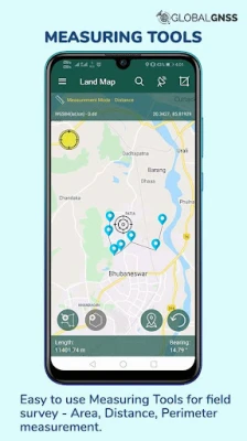
- Calculate the area and distance
- GIS data collector
- Survey using images for any location is available, with multiple export options.
- One set of attributes can be used across multiple surveys.
- GPS land area calculator
- Attributes can be imported from any other project or device.
-Post process of data can be performed with software like ArcGIS, ArcGIS online or
qGIS.
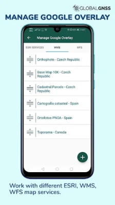
- WMS and WFS Surveyor tiled maps are supported, load topographic and orthophoto maps, geological surveys, cadastral information.
- Currently 4 methods of data collections are supported, GPS / GNSS location, map cursor location,GIS Tracker, point projection using angle and distance.
-Mapit GIS survey on multiple kinds of GIS maps.
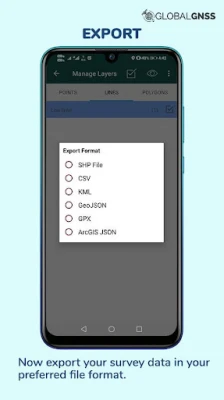
-Various Export file formats for GIS data are CSV, KML, and GeoJSON.
- With external Bluetooth GPS/GNSS device connected, NTRIP/RTK data can be utilised for accuracy.
- Survey on online gis maps, and GIS offline maps(supports mbtiles.
- Direct export to Dropbox,Google Drive, FTP location.
- Import point, line and polygon layer in CSV, KML or geojson file.
- Possibility to view multiple layers including points, lines and polygons at the same time.
- Export in .SHP format.
- Export in GPX format.
- Possibility to group the data into survey layers - each survey layer may have a default set of attributes.
- Create new polygon or line features and measure details like area, length and perimeter.
- Backup management.
- Works with GEOID Model to provide elevation for a point.
- Receive Mock Location from 3rd party application.
- Coordinate System Geoid EGM96
Supports Android OS 4.4 and above
This application is made ads-free and hence it will increase your productivity. For any concern regarding the installation or functionality raise a ticket at: http://globalgnss.com/support/
Visit us at www.globalgnss.com.
Land map is an application for surveyors. Precision and accuracy are the two cornerstones that enables Land Map for GIS survey, GIS Data handling, data collection, and analysis.
The applications UI enables faster data collection while the software allows to work in numerous file formats like CSV, KML, and GeoJSONwhich helps in GIS Mapping.
Land Map is a GPS/GNSS based survey application that uses GPS data collection. It will be used for various types of environmental surveys and field surveys while also enabling the GIS data collection to be faster and efficient.
Using internal GPS & external GPS, this survey application is a must have for surveys including Field Survey, and Land Survey
- Survey Application features:
- Calculate the area and distance
- GIS data collector
- Survey using images for any location is available, with multiple export options.
- One set of attributes can be used across multiple surveys.
- GPS land area calculator
- Attributes can be imported from any other project or device.
-Post process of data can be performed with software like ArcGIS, ArcGIS online or
qGIS.
- WMS and WFS Surveyor tiled maps are supported, load topographic and orthophoto maps, geological surveys, cadastral information.
- Currently 4 methods of data collections are supported, GPS / GNSS location, map cursor location,GIS Tracker, point projection using angle and distance.
-Mapit GIS survey on multiple kinds of GIS maps.
-Various Export file formats for GIS data are CSV, KML, and GeoJSON.
- With external Bluetooth GPS/GNSS device connected, NTRIP/RTK data can be utilised for accuracy.
- Survey on online gis maps, and GIS offline maps(supports mbtiles.
- Direct export to Dropbox,Google Drive, FTP location.
- Import point, line and polygon layer in CSV, KML or geojson file.
- Possibility to view multiple layers including points, lines and polygons at the same time.
- Export in .SHP format.
- Export in GPX format.
- Possibility to group the data into survey layers - each survey layer may have a default set of attributes.
- Create new polygon or line features and measure details like area, length and perimeter.
- Backup management.
- Works with GEOID Model to provide elevation for a point.
- Receive Mock Location from 3rd party application.
- Coordinate System Geoid EGM96
Supports Android OS 4.4 and above
This application is made ads-free and hence it will increase your productivity. For any concern regarding the installation or functionality raise a ticket at: http://globalgnss.com/support/
Visit us at www.globalgnss.com.
application description
Rate the App
Add Comment & Review
User Reviews
Based on 0 reviews
No reviews added yet.
Comments will not be approved to be posted if they are SPAM, abusive, off-topic, use profanity, contain a personal attack, or promote hate of any kind.


More »

Popular Apps

Rakuten Viber Messenger Viber Media

Turboprop Flight Simulator Pilot Modern Prop Planes

Yandere Schoolgirls Online Sandbox Multiplayer HighSchool

VPN proxy - TipTop VPN TipTopNet

Highway Bike Traffic Racer 3D Motorcycle Rider Driving Games

KakaoTalk : Messenger Kakao Corp.

SchoolGirl AI 3D Anime Sandbox Kurenai Games

Spirit Chat Grenfell Music

World of Tanks Blitz · Online PvP Tank Game, Not War

Wings of Heroes: plane games WW2 5v5 flight simulator game
More »
Editor's Choice
VPN proxy - TipTop VPN TipTopNet
Highway Bike Traffic Racer 3D Motorcycle Rider Driving Games

ZOMBIE HUNTER: Offline Games 3D Shooting Apocalypse Gun War

Endless Learning Academy ABC,123,Emotions (Kids 2-5)
Spirit Chat Grenfell Music
Yandere Schoolgirls Online Sandbox Multiplayer HighSchool

JP Schoolgirl Supervisor Multi Saori Sato's Developer
SchoolGirl AI 3D Anime Sandbox Kurenai Games
 Android
 IOS
IOS Windows
 Mac
Mac Linux
Linux