

Latest Version
Update
June 12, 2025
June 12, 2025
Developer
Ubicarta
Ubicarta
Categories
Travel & Local
Travel & Local
Platforms
Android
Android
Downloads
0
0
License
Free
Free
Package Name
IGNrando' – France hiking maps
IGNrando' – France hiking maps
Report
Report a Problem
Report a Problem
More About IGNrando' – France hiking maps
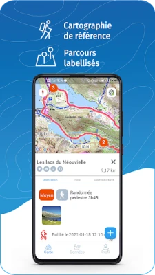
IGNrando’ is a collaborative platform for sharing routes and points of interest (POIs) related to outdoor activities in France.
RICH DATA OFFER
• Tens of thousands of routes and POIs all accross Metropolitan and Overseas France
• Choose the activity, difficulty level and route length to find routes around you or near any other place
• Download or mark as favorite the desired routes or POIs
MAPS & LAYERS IN FREE ACCESS (with internet connection)
• Plan IGN: most updated map, suitable for all activities
• Aerial photos (IGN)
• OpenStreetMap Outdoors: world map with hiking routes & contour lines
• OpenCycleMap: world map with cycling routes & contour lines
∙ Spain IGN map
∙ Swisstopo map
∙ Emergency calls (112) mobile network coverage map for France
∙ OpenSnowMap
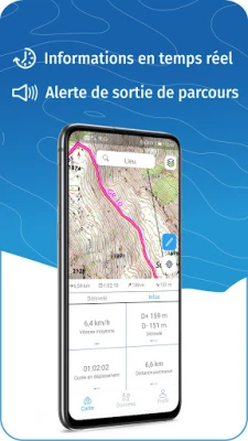
GPS GUIDING ALONG ROUTES
• See your progression on the altitude graph
• Get alerted if you exit the route
GPS TRACKING AND DATA CREATION
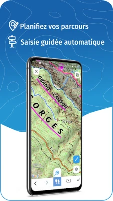
• Record your own routes with GPS tracking
• Quickly create routes on-device with the automatic routing tool that follows roads and paths (online only, with subscription)
• Create Points of interest
• Send your routes to ignrando.fr for backup or to publish them
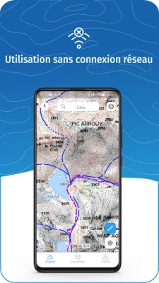
OFFLINE USE
• The GPS keeps working even without internet: see your position on the map, use GPS guiding and record routes
• Downloaded routes: descriptions, photos and guiding remain accessible
• Downloaded maps (with subscription)
Useful tip: Enabling Airplane Mode or disabling Mobile Data improves battery life, without affecting the Location Services (GPS)
IGN MAPS SUBSCRIPTION
• Create routes with pedestrian and vehicle routing
• View & download the following maps & layers:
∙ All free version maps
∙ IGN maps (various scales)
∙ IGN 1:25k topo maps (Top 25): the famous French topographical maps available at all zoom levels
∙ 1950 IGN maps
∙ Military maps (1820-1866)
∙ ICAO aeronautical charts
∙ France mobile network operators coverage maps
∙ Slopes > 30° (useful for winter activites)
∙ Cadastral parcels layer
∙ DFCI grid (forest fire protection grid)
• Drones flight restriction areas
∙ Roads & paths layer (only available with Aerial photos)
Play Store subscription
• Linked to Google account
• Automatic renewal unless cancelled at least 24 hours before the end of the current period
• Auto-renewal may be turned off after purchase
Ubicarta store subscription
• Linked to your Ubicarta account
• Purchase & manage your subscription on ignrandoapp.ubicarta.com
• Can be used on 3 devices at the same time (Android & iOS)
Use an SD card to store your data
Free space on your device.
——————————————————————
The app uses your network connection to stream maps or to download content or maps. Carrier charges may apply.
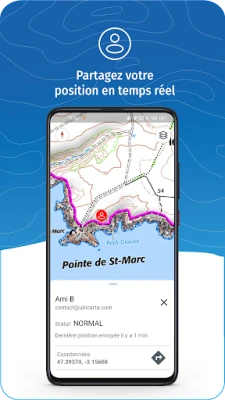
The app uses your device location to display it on the map, to record tracks and to share it to your friends via the location sharing feature.
Got ideas to improve the IGNrando' app
Write us on: [email protected]
• Tens of thousands of routes and POIs all accross Metropolitan and Overseas France
• Choose the activity, difficulty level and route length to find routes around you or near any other place
• Download or mark as favorite the desired routes or POIs
MAPS & LAYERS IN FREE ACCESS (with internet connection)
• Plan IGN: most updated map, suitable for all activities
• Aerial photos (IGN)
• OpenStreetMap Outdoors: world map with hiking routes & contour lines
• OpenCycleMap: world map with cycling routes & contour lines
∙ Spain IGN map
∙ Swisstopo map
∙ Emergency calls (112) mobile network coverage map for France
∙ OpenSnowMap
GPS GUIDING ALONG ROUTES
• See your progression on the altitude graph
• Get alerted if you exit the route
GPS TRACKING AND DATA CREATION
• Record your own routes with GPS tracking
• Quickly create routes on-device with the automatic routing tool that follows roads and paths (online only, with subscription)
• Create Points of interest
• Send your routes to ignrando.fr for backup or to publish them
OFFLINE USE
• The GPS keeps working even without internet: see your position on the map, use GPS guiding and record routes
• Downloaded routes: descriptions, photos and guiding remain accessible
• Downloaded maps (with subscription)
Useful tip: Enabling Airplane Mode or disabling Mobile Data improves battery life, without affecting the Location Services (GPS)
IGN MAPS SUBSCRIPTION
• Create routes with pedestrian and vehicle routing
• View & download the following maps & layers:
∙ All free version maps
∙ IGN maps (various scales)
∙ IGN 1:25k topo maps (Top 25): the famous French topographical maps available at all zoom levels
∙ 1950 IGN maps
∙ Military maps (1820-1866)
∙ ICAO aeronautical charts
∙ France mobile network operators coverage maps
∙ Slopes > 30° (useful for winter activites)
∙ Cadastral parcels layer
∙ DFCI grid (forest fire protection grid)
• Drones flight restriction areas
∙ Roads & paths layer (only available with Aerial photos)
Play Store subscription
• Linked to Google account
• Automatic renewal unless cancelled at least 24 hours before the end of the current period
• Auto-renewal may be turned off after purchase
Ubicarta store subscription
• Linked to your Ubicarta account
• Purchase & manage your subscription on ignrandoapp.ubicarta.com
• Can be used on 3 devices at the same time (Android & iOS)
Use an SD card to store your data
Free space on your device.
——————————————————————
The app uses your network connection to stream maps or to download content or maps. Carrier charges may apply.
The app uses your device location to display it on the map, to record tracks and to share it to your friends via the location sharing feature.
Got ideas to improve the IGNrando' app
Write us on: [email protected]
application description
Rate the App
Add Comment & Review
User Reviews
Based on 0 reviews
No reviews added yet.
Comments will not be approved to be posted if they are SPAM, abusive, off-topic, use profanity, contain a personal attack, or promote hate of any kind.


More »

Popular Apps

VPN proxy - TipTop VPN TipTopNet

Rakuten Viber Messenger Viber Media

Turboprop Flight Simulator Pilot Modern Prop Planes

Highway Bike Traffic Racer 3D Motorcycle Rider Driving Games

Yandere Schoolgirls Online Sandbox Multiplayer HighSchool

SchoolGirl AI 3D Anime Sandbox Kurenai Games
Spirit Chat Grenfell Music

ZOMBIE HUNTER: Offline Games 3D Shooting Apocalypse Gun War

KakaoTalk : Messenger Kakao Corp.

Endless Learning Academy ABC,123,Emotions (Kids 2-5)
More »
Editor's Choice

Belet Video JAN tehnologiýa
VPN proxy - TipTop VPN TipTopNet
Highway Bike Traffic Racer 3D Motorcycle Rider Driving Games
ZOMBIE HUNTER: Offline Games 3D Shooting Apocalypse Gun War
Endless Learning Academy ABC,123,Emotions (Kids 2-5)
Spirit Chat Grenfell Music
Yandere Schoolgirls Online Sandbox Multiplayer HighSchool

JP Schoolgirl Supervisor Multi Saori Sato's Developer
SchoolGirl AI 3D Anime Sandbox Kurenai Games
 Android
 IOS
IOS Windows
 Mac
Mac Linux
Linux