
Latest Version
Version
265.0
265.0
Update
June 21, 2025
June 21, 2025
Developer
Gps Nautical Charts
Gps Nautical Charts
Categories
Travel & Local
Travel & Local
Platforms
Android
Android
Downloads
0
0
License
Free
Free
Package Name
i-Boating:Marine Navigation
i-Boating:Marine Navigation
Report
Report a Problem
Report a Problem
More About i-Boating:Marine Navigation
#1 Marine Charts App offers offline nautical charts, inland river navigation charts, and lake contour maps w/ fishing AI, relief shading& lake depths. Only marine navigation app to have boat route assistance with Voice Prompts.Like having a Marine Chart plotter in one app!
Nautical Charts w/course up orientation. Incl Tide Charts & Currents prediction for nautical navigation. Create Boat routes / Waypoints, or import existing GPX/KML routes on device. Has Marine AIS(NMEA) support.
Superset of Navionics,C-Map,Lowrance,Argo,Windy & Predict Wind!
►FEATURES
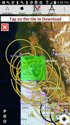
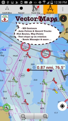
√ GPU accelerated offline vector NOAA charts/ENC charts (text stays upright)
√ Lake depth map shading/safety lake depth contours:custom boat safety depth
√ Maritime Aids to Boat Navigation : Beacons,Buoys,Boat Launch areas,Boat Ramps,Marina, Fishing Attractors
√ Record marine tracks, Autofollow with real-time track overlay
√ Voice Prompts for marine navigation
√ HD 1ft/3ft depth lake contour maps for anglers for selected lake maps: for fishing/trolling(freshwater/saltwater).
√ GPX/KML for boat route.
√ Seamless marine chart quilting: Coastal, Approaches,Harbour & Inland ENC(Electronic Marine Charts)
√ Superset of Navionics, C-Map,Lowrance,Argo,Wavve,Savvy Navvy,Predict Wind & Windy.
√ Waypoints
√ Tide & Currents.
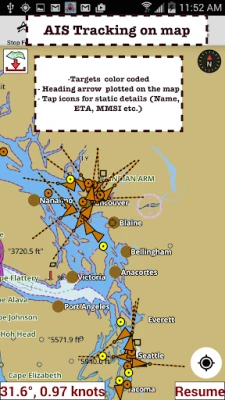
√ Marine AIS
√ Anchor Alarm
√ Magnify Text & Icons
√ Wind Prediction Overlay
√ Bearing True/Magnetic
► Fishing Hot Spots AI
►Lake Temperature Maps(Thermoclines 1°F (0.5° C)
►Relief Shading
► MAPS
Marine chartplotters details!
Unlimited updates for 1 year.
USA:Maps incl NOAA marine charts,ENC,USACE inland river maps & freshwater lake bathymetry maps for 75K+ lakes. Charts incl HD/1ft bathymetry. Incl NOAA marine charts(rasters) w/ NOAA ENC coverage.
Canada:CHS data Incl Great lakes,Alberta & Ontario lakes,Lake Simcoe&Trent Severn Canal,Quebec reservoirs.
UK/Ireland:UKHO marine charts
Germany:BSH charts,Waterways & rivers.
France
Europe Inland Rivers:Donau/Danube/Dunaja,Rhine,Rhein
Australia
Netherland/Holland
Croatia
Finland
Norway
Sweden
Brazil
Spain
Malta,Cypress,Mediterranean Sea
Caribbean
New Zealand
Denmark,Greenland,Faroe
Seychelles,Mauritius,Tanzania
Falklands
Malaysia,South China Sea
Persian/Arabian Gulf,Red Sea
South Africa
Argentina
Iceland
Fiji
Estonia,Latvia,Poland,Lithuania
Turkey,Greece,Italy
►Instrumentation
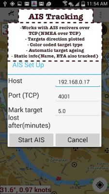
√Marine AIS & (NMEA AIS and GPS - TCP/UDP)
√Wind direction & Speed,Marine Sonar depth,Water temperature
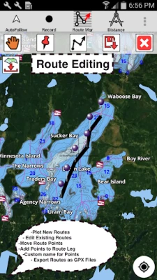
►ROUTE MANAGEMENT/TRIP PLANNING
√Create/Edit/Reverse Boat Routes
√Waypoints mgt
√Import GPX,KML & KMZ files
√Share/Export Routes,Boating log,Tracks&Markers
►BOAT NAVIGATION
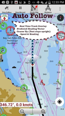
√Auto Follow
*Real Time Overlay & Predicted Path Vector
*Course Up
*Speed & Heading
√ Route Assistance With Voice Prompts
*approaching boating route marker prompt
*RT nautical distance & ETA
*sailing/boating off route/wrong direction
√ Record Tracks
►TIDE & CURRENTS
*High/Low Tides
*Tidal Current Prediction
►Marine Weather
*GFS+ ECMWF
►SHARING
*Export GPX.
►Satellite Imagery
►USA Marine Charts
*Texas Lakes Texoma,Eufaula,Toledo Bend
*California Lakes Tahoe,Shasta
Pennsylvania Lakes Raystown
Florida Lakes Okeechobee,Kissimmee
*Minnesota Lakes Minnetonka,Waconia,Leech,Mille Lacs
*Massachussets lakes Quabbin
*Missouri Lakes Truman
*Ohio Lake maps Lake hoover
*Wisconsin Lakes Winnebago,Pepin
* Utah Lake Powell,Bear
*Maine Lake Sebago
*Alaska Lakes:Winnipesaukee
*Tennessee Lake Barkley,Norris,Watts Bar
*South Carolina Lake Keowee,Hartwell,Murray
*Lake Michigan,Huron,Ontario,Superior,Erie
►Canada Lakes Maps
*Lac Saint Jean
*Ontario Lake depth maps
*Rideau Canal-Ottawa River
*British Columbia Marine Charts
*Pacific Coast-Vancouver-Haida Gwaii
*Nova Scotia -Bay of Fundy
*Quebec-Anticosti Island
*Newfoundland
*St Lawrence river
*Manitoba & Saskatchewan
*Georgian Bay
*Puget Sound
►UK Nautical Charts
*Scotland
*Thames Estuary
*Ireland
►Australia Marine & Lake Maps
*NSW
*Queensland
Superset of Navionics,C-Map,Lowrance,Argo,Windy & Predict Wind!
►FEATURES
√ GPU accelerated offline vector NOAA charts/ENC charts (text stays upright)
√ Lake depth map shading/safety lake depth contours:custom boat safety depth
√ Maritime Aids to Boat Navigation : Beacons,Buoys,Boat Launch areas,Boat Ramps,Marina, Fishing Attractors
√ Record marine tracks, Autofollow with real-time track overlay
√ Voice Prompts for marine navigation
√ HD 1ft/3ft depth lake contour maps for anglers for selected lake maps: for fishing/trolling(freshwater/saltwater).
√ GPX/KML for boat route.
√ Seamless marine chart quilting: Coastal, Approaches,Harbour & Inland ENC(Electronic Marine Charts)
√ Superset of Navionics, C-Map,Lowrance,Argo,Wavve,Savvy Navvy,Predict Wind & Windy.
√ Waypoints
√ Tide & Currents.
√ Marine AIS
√ Anchor Alarm
√ Magnify Text & Icons
√ Wind Prediction Overlay
√ Bearing True/Magnetic
► Fishing Hot Spots AI
►Lake Temperature Maps(Thermoclines 1°F (0.5° C)
►Relief Shading
► MAPS
Marine chartplotters details!
Unlimited updates for 1 year.
USA:Maps incl NOAA marine charts,ENC,USACE inland river maps & freshwater lake bathymetry maps for 75K+ lakes. Charts incl HD/1ft bathymetry. Incl NOAA marine charts(rasters) w/ NOAA ENC coverage.
Canada:CHS data Incl Great lakes,Alberta & Ontario lakes,Lake Simcoe&Trent Severn Canal,Quebec reservoirs.
UK/Ireland:UKHO marine charts
Germany:BSH charts,Waterways & rivers.
France
Europe Inland Rivers:Donau/Danube/Dunaja,Rhine,Rhein
Australia
Netherland/Holland
Croatia
Finland
Norway
Sweden
Brazil
Spain
Malta,Cypress,Mediterranean Sea
Caribbean
New Zealand
Denmark,Greenland,Faroe
Seychelles,Mauritius,Tanzania
Falklands
Malaysia,South China Sea
Persian/Arabian Gulf,Red Sea
South Africa
Argentina
Iceland
Fiji
Estonia,Latvia,Poland,Lithuania
Turkey,Greece,Italy
►Instrumentation
√Marine AIS & (NMEA AIS and GPS - TCP/UDP)
√Wind direction & Speed,Marine Sonar depth,Water temperature
►ROUTE MANAGEMENT/TRIP PLANNING
√Create/Edit/Reverse Boat Routes
√Waypoints mgt
√Import GPX,KML & KMZ files
√Share/Export Routes,Boating log,Tracks&Markers
►BOAT NAVIGATION
√Auto Follow
*Real Time Overlay & Predicted Path Vector
*Course Up
*Speed & Heading
√ Route Assistance With Voice Prompts
*approaching boating route marker prompt
*RT nautical distance & ETA
*sailing/boating off route/wrong direction
√ Record Tracks
►TIDE & CURRENTS
*High/Low Tides
*Tidal Current Prediction
►Marine Weather
*GFS+ ECMWF
►SHARING
*Export GPX.
►Satellite Imagery
►USA Marine Charts
*Texas Lakes Texoma,Eufaula,Toledo Bend
*California Lakes Tahoe,Shasta
Pennsylvania Lakes Raystown
Florida Lakes Okeechobee,Kissimmee
*Minnesota Lakes Minnetonka,Waconia,Leech,Mille Lacs
*Massachussets lakes Quabbin
*Missouri Lakes Truman
*Ohio Lake maps Lake hoover
*Wisconsin Lakes Winnebago,Pepin
* Utah Lake Powell,Bear
*Maine Lake Sebago
*Alaska Lakes:Winnipesaukee
*Tennessee Lake Barkley,Norris,Watts Bar
*South Carolina Lake Keowee,Hartwell,Murray
*Lake Michigan,Huron,Ontario,Superior,Erie
►Canada Lakes Maps
*Lac Saint Jean
*Ontario Lake depth maps
*Rideau Canal-Ottawa River
*British Columbia Marine Charts
*Pacific Coast-Vancouver-Haida Gwaii
*Nova Scotia -Bay of Fundy
*Quebec-Anticosti Island
*Newfoundland
*St Lawrence river
*Manitoba & Saskatchewan
*Georgian Bay
*Puget Sound
►UK Nautical Charts
*Scotland
*Thames Estuary
*Ireland
►Australia Marine & Lake Maps
*NSW
*Queensland
application description
Rate the App
Add Comment & Review
User Reviews
Based on 0 reviews
No reviews added yet.
Comments will not be approved to be posted if they are SPAM, abusive, off-topic, use profanity, contain a personal attack, or promote hate of any kind.


More »

Popular Apps

VPN proxy - TipTop VPN TipTopNet

Rakuten Viber Messenger Viber Media
Turboprop Flight Simulator Pilot Modern Prop Planes

Yandere Schoolgirls Online Sandbox Multiplayer HighSchool
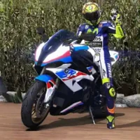
Highway Bike Traffic Racer 3D Motorcycle Rider Driving Games

SchoolGirl AI 3D Anime Sandbox Kurenai Games
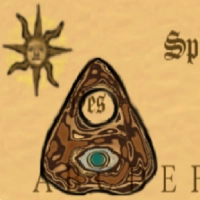
Spirit Chat Grenfell Music

ZOMBIE HUNTER: Offline Games 3D Shooting Apocalypse Gun War

KakaoTalk : Messenger Kakao Corp.

Endless Learning Academy ABC,123,Emotions (Kids 2-5)
More »
Editor's Choice

Belet Video JAN tehnologiýa
VPN proxy - TipTop VPN TipTopNet
Highway Bike Traffic Racer 3D Motorcycle Rider Driving Games
ZOMBIE HUNTER: Offline Games 3D Shooting Apocalypse Gun War
Endless Learning Academy ABC,123,Emotions (Kids 2-5)
Spirit Chat Grenfell Music
Yandere Schoolgirls Online Sandbox Multiplayer HighSchool

JP Schoolgirl Supervisor Multi Saori Sato's Developer
SchoolGirl AI 3D Anime Sandbox Kurenai Games
 Android
 IOS
IOS Windows
 Mac
Mac Linux
Linux