Recommended Searches
games


Latest Version
Version
5.50-568
5.50-568
Update
August 11, 2024
August 11, 2024
Developer
Waymarked Trails LTD
Waymarked Trails LTD
Categories
Maps And Navigation
Maps And Navigation
Platforms
Android
Android
Downloads
0
0
License
Free
Free
Package Name
HiiKER: The Offline Hiking app
HiiKER: The Offline Hiking app
Report
Report a Problem
Report a Problem
More About HiiKER: The Offline Hiking app
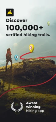
HiiKER is an award-winning hiking app that is dedicated to building tools specifically for the hiking community.
Here are some of the key features of HiiKER (expanded below)
* Discover over 100,000 verified hiking trails
* Find campsites, hotels, huts, stores, motels, water sources etc
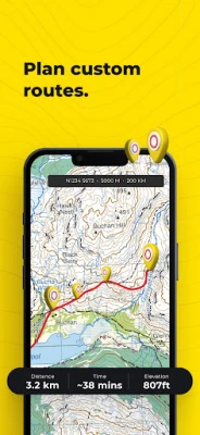
* Plan your own custom hiking route
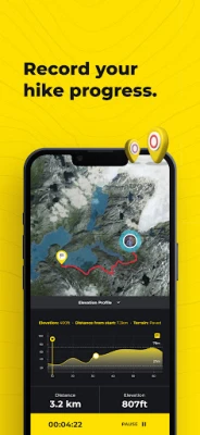
* Record your Hikes
* Download hiking trails for FREE to navigate offline
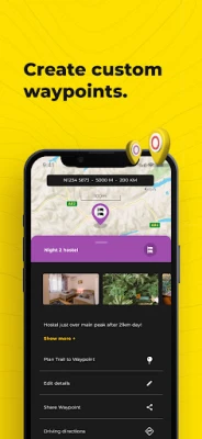
* Create custom waypoints for Nav and Geocaching
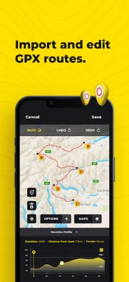
* Import & Export GPX files for Free
* Choose from High-Resolution Map layers
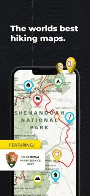
Download thousands of Hiking trail maps for FREE
With HiiKER, you can download over 87,000 of the world’s best hiking, walking and backpacking trails right to your smartphone for free. Looking for the perfect hiking trail? You’ll find the trail that’s right for you with our powerful trail search tool. And navigate it completely offline, for free.
Points of Interest / Accommodation
You’ll find thousands of accommodation and amenity options for your adventures. Plan ahead with the perfect lunch spot, campsite, resupply town or maybe even a 5-star hotel on your hiking trip.
Plan custom hiking routes
The HiiKER Route Planner will enable you to blaze your own trail and plan a custom hiking route. Download your planned hiking route to your device for free and navigate offline. You can even share your hiking route with others or with your smart device, like Garmin, Apple watch or Google Fit.
Free Offline Hiking Maps
With HiiKER you can download all your favourite trails to your phone to use offline FOR FREE - even in airplane mode, so you can stay safe on the trail.
Waypoints & Geocaching
Place custom waypoints on any map and edit the details of the waypoint. Waypoints can be used to note campsites, gps coordinates, geocache locations, checkpoints and many other uses.
Import GPX files
Got a GPX file from a friend or another app like alltrails, onx, gaia gps, garmin, strava, komoot? Import it to HiiKER and make your own edits to the route before hitting the trail.
Record your Hikes
The HiiKER Tracker records your hiking activity and gives you in-depth detail about your adventures that you can share to Strava, Garmin and with your hiking community.
High-Resolution Map layers
We are building the most comprehensive selection of FREE map layers available. You'll find the layer that is best suited to your hike. These include
Open street maps (OSM)
Satellite
Nature
Mobile Atlas
Landscape
Pioneer
Transport
Free GPX Download
Export GPX files of one of the thousands of hiking trails on HiiKER for FREE. Sync them with your other gps devices, such as Garmin, suunto, coros etc.
HiiKER PRO+ pricing starts from $4.99 per month or $49.99 per year.
[PRO+] Measure the Distance
Use our handy measurement tool to know what distance, terrain and elevation lie ahead.
[PRO+] Stage by stage breakdown
Planning a longer hike and want to divide the trail into smaller segments? Our stage-by-stage breakdown helps you plan your days better with clever distance and elevation management.
[PRO+] Premium High-Resolution maps
Upgrading to HiiKER PRO+ gets you access to some of the world's best map developers in the world on the platform. These high-resolution maps include
US National Forests
USGS
National Park Service
Ordnance Survey UK
EastWest Mapping
IGN
OSi (Ireland) / Tailte
Swiss Topo
All of these maps can be used in conjunction with other HiiKER features.
Quality Data
We don’t just put any trail on HiiKER. We partner with trail organisations, National parks and other trusted sources around the world to bring you the most up-to-date and official trail data available.
These organisations are critical to the enjoyment and safety of hikers. As many are voluntary or NFP organisations, we give users the ability to donate to them for the valuable work they do.
Help and Support
Contact us at [email protected]
Legal
Terms of Service: https://hiiker.app/terms-of-service
* Discover over 100,000 verified hiking trails
* Find campsites, hotels, huts, stores, motels, water sources etc
* Plan your own custom hiking route
* Record your Hikes
* Download hiking trails for FREE to navigate offline
* Create custom waypoints for Nav and Geocaching
* Import & Export GPX files for Free
* Choose from High-Resolution Map layers
Download thousands of Hiking trail maps for FREE
With HiiKER, you can download over 87,000 of the world’s best hiking, walking and backpacking trails right to your smartphone for free. Looking for the perfect hiking trail? You’ll find the trail that’s right for you with our powerful trail search tool. And navigate it completely offline, for free.
Points of Interest / Accommodation
You’ll find thousands of accommodation and amenity options for your adventures. Plan ahead with the perfect lunch spot, campsite, resupply town or maybe even a 5-star hotel on your hiking trip.
Plan custom hiking routes
The HiiKER Route Planner will enable you to blaze your own trail and plan a custom hiking route. Download your planned hiking route to your device for free and navigate offline. You can even share your hiking route with others or with your smart device, like Garmin, Apple watch or Google Fit.
Free Offline Hiking Maps
With HiiKER you can download all your favourite trails to your phone to use offline FOR FREE - even in airplane mode, so you can stay safe on the trail.
Waypoints & Geocaching
Place custom waypoints on any map and edit the details of the waypoint. Waypoints can be used to note campsites, gps coordinates, geocache locations, checkpoints and many other uses.
Import GPX files
Got a GPX file from a friend or another app like alltrails, onx, gaia gps, garmin, strava, komoot? Import it to HiiKER and make your own edits to the route before hitting the trail.
Record your Hikes
The HiiKER Tracker records your hiking activity and gives you in-depth detail about your adventures that you can share to Strava, Garmin and with your hiking community.
High-Resolution Map layers
We are building the most comprehensive selection of FREE map layers available. You'll find the layer that is best suited to your hike. These include
Open street maps (OSM)
Satellite
Nature
Mobile Atlas
Landscape
Pioneer
Transport
Free GPX Download
Export GPX files of one of the thousands of hiking trails on HiiKER for FREE. Sync them with your other gps devices, such as Garmin, suunto, coros etc.
HiiKER PRO+ pricing starts from $4.99 per month or $49.99 per year.
[PRO+] Measure the Distance
Use our handy measurement tool to know what distance, terrain and elevation lie ahead.
[PRO+] Stage by stage breakdown
Planning a longer hike and want to divide the trail into smaller segments? Our stage-by-stage breakdown helps you plan your days better with clever distance and elevation management.
[PRO+] Premium High-Resolution maps
Upgrading to HiiKER PRO+ gets you access to some of the world's best map developers in the world on the platform. These high-resolution maps include
US National Forests
USGS
National Park Service
Ordnance Survey UK
EastWest Mapping
IGN
OSi (Ireland) / Tailte
Swiss Topo
All of these maps can be used in conjunction with other HiiKER features.
Quality Data
We don’t just put any trail on HiiKER. We partner with trail organisations, National parks and other trusted sources around the world to bring you the most up-to-date and official trail data available.
These organisations are critical to the enjoyment and safety of hikers. As many are voluntary or NFP organisations, we give users the ability to donate to them for the valuable work they do.
Help and Support
Contact us at [email protected]
Legal
Terms of Service: https://hiiker.app/terms-of-service
application description
Rate the App
Add Comment & Review
User Reviews
Based on 28 reviews
No reviews added yet.
Comments will not be approved to be posted if they are SPAM, abusive, off-topic, use profanity, contain a personal attack, or promote hate of any kind.


More »

Popular Apps

Rakuten Viber Messenger Viber Media

Turboprop Flight Simulator Pilot Modern Prop Planes

Yandere Schoolgirls Online Sandbox Multiplayer HighSchool

VPN proxy - TipTop VPN TipTopNet

Highway Bike Traffic Racer 3D Motorcycle Rider Driving Games

KakaoTalk : Messenger Kakao Corp.

SchoolGirl AI 3D Anime Sandbox Kurenai Games

Spirit Chat Grenfell Music

World of Tanks Blitz · Online PvP Tank Game, Not War

Wings of Heroes: plane games WW2 5v5 flight simulator game
More »
Editor's Choice
VPN proxy - TipTop VPN TipTopNet
Highway Bike Traffic Racer 3D Motorcycle Rider Driving Games

ZOMBIE HUNTER: Offline Games 3D Shooting Apocalypse Gun War

Endless Learning Academy ABC,123,Emotions (Kids 2-5)
Spirit Chat Grenfell Music
Yandere Schoolgirls Online Sandbox Multiplayer HighSchool

JP Schoolgirl Supervisor Multi Saori Sato's Developer
SchoolGirl AI 3D Anime Sandbox Kurenai Games
 Android
 IOS
IOS Windows
 Mac
Mac Linux
Linux